Sale on canvas prints! Use code ABCXYZ at checkout for a special discount!

Boundary: Bleed area may not be visible.

Inside Message (Optional)
Inside View

by Blue Monocle
$4.95
Quantity
The more you buy... the more you save.
Orientation
Image Size
Product Details
Our greeting cards are 5" x 7" in size and are produced on digital offset printers using 100 lb. paper stock. Each card is coated with a UV protectant on the outside surface which produces a semi-gloss finish. The inside of each card has a matte white finish and can be customized with your own message up to 500 characters in length. Each card comes with a white envelope for mailing or gift giving.
Design Details
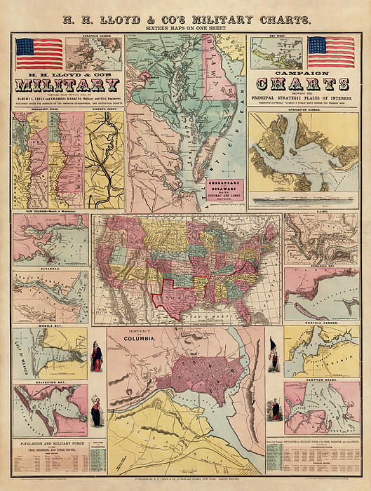
Shows sixteen maps covering places of interest in the early part of the Civil War, generally indicating forts, towns, railroads, and rivers. Shows... more
Ships Within
2 - 3 business days
Shows sixteen maps covering places of interest in the early part of the Civil War, generally indicating forts, towns, railroads, and rivers. Shows maps of Annapolis, Key West, the Mississippi River, Chesapeake Bay and vicinity, Charleston, New Orleans, Savannah, Mobile Bay, the United States, Cairo, Pensacola Bay, Galveston Bay, Norfolk, Hampton Roads, Washington, D.C., and Harpers Ferry.
Original title: H. H. Lloyd and Co's. Campaign Military Charts Showing the Principal Strategic Places of Interest
Blue Monocle is an imaging studio and print shop specializing in the digital restoration and presentation of antique maps.
$4.95


There are no comments for Antique Civil War Map by Egbert L. Viele - circa 1861. Click here to post the first comment.